Guthrie Mountain

Free-state sympathizer or a case of jumping to the wrong conclusion? You decide.

Here is a tale about a lynching on Guthrie Mountain in Bourbon County. It was told in 1932 by Charles E. Cory to the Kansas Historical Society. I am reprinting much of it as Cory wrote it.

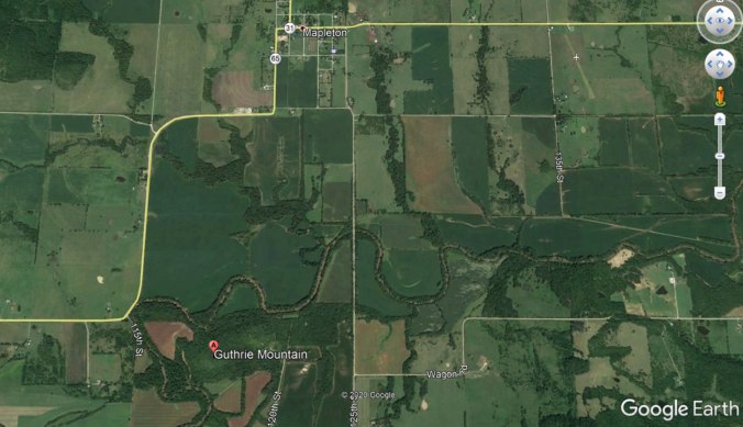
“Away back in the later territorial days [May 30, 1854, until January 29, 1861, the hanging took place on a dark cold Sunday morn, in February, 1860, a little after midnight], when Bourbon county was in the ‘region beyant the law,’ a young man named [John R.] Guthrie was caught up near Mapleton riding somebody else’s horse.”
“Just across the river south of Mapleton in the Little Osage bottom is a little round hill about three hundred feet high shaped almost exactly like an overturned soup bowl. [The farmers who caught up with Guthrie] adjourned to the top of that hill. There they elected a judge and a sheriff and a prosecuting attorney, [and appointed a jury]. [Guthrie we suppose fended for himself, poorly, as he admitted his guilt.*]… After the verdict and the proper sentence, the sheriff had no place to keep the man [not wanting to take him home to his family], so he executed the sentence at once by hanging him to the limb of a jack oak tree nearby. His body was buried where it was cut dawn.”

“By the way, that hill is the same `pretty little hill’  where Lieut. Zebulon M. Pike [on his way west to the Pawnee villages on the Republican River, stopped and] ate fried venison steak that September morning in 1806, as he notes in his journal. It is still called Guthrie mountain, and is one of the real beauty spots of old Bourbon.”

*Others say he was hung for being a Free State Sympathizer, some say he was a schoolteacher come to Mapleton to teach his first class. Some say he cursed his killers and condemned them to a violent death. Some say that happened. Some say his ghost still haunts Guthrie Mountain.

Choose what you want to believe, but the most lurid tale was told by Chance Hoener in the Pittsburg Morning Sun.

There is more to the story that you can read online.

guthrie-mountain

Ft. Row

Nothing remains of Ft. Row. And the story is little known of the thousands of Indians who died getting there and afterwards.

ft-row-plaque

Even the site is uncertain though it is known to be on the south bank of the Verdigris River near the present town of Coyville.  Nine miles north of Fredonia on Harper Road, just as the road angles west to follow the southern bank of the Verdigris River, one comes across a commemorative plaque.

Opothleyahola

Late in 1861, Opothleyahola (Opothle Yahola), leader of a band of Creek Indian loyal to the Union, led an exodus of some 9,000 Creeks, Seminoles, and mixed Blacks and Indians, seeking refuge in Kansas from Confederate soldiers. Opposing Indian bands and Confederate Forces followed them, leading to the Battle of Round Mountain on November 19, Chusto-Talasah on December 9, and, finally, Chustenahlah on December 26.

At Chustenahlah in Oklahoma, the out-matched Creeks and Seminoles abandoned their livestock and wagons and fled for their lives in the snow and ice. Ft. Row was hastily built by Union soldiers, but it too was ill-equipped to handle such a large number of refugees. Many died on the way to Ft. Row, more died of exposure and lack of care. Many of the Indians moved on to Ft. Belmont in Woodson County. This location had only a few cabins and provided little relief.

Among the dead were , and Opthleyahola himself in 1863.

Of the surviving Indian braves, more than 1,000 made their way to Camp Hunter in Humboldt, Kansas where, along with Seminoles and African-Creeks and African Seminoles, they were inducted into the Union Army as the First Indian Regiment.  They would first see action at the Battle of Prairie Grove in Arkansas, on December 7, 1862. This battle re-established Union control of northwest Arkansas. They also saw action on the battlefields of Missouri and the Indian Territory and were mustered out in May 1865.

After the Civil War, the reconstruction treaty of 1866 required the cession of 3.2 million acres – approximately half of the Muscogee (Creek) domain.