Osage Indians in Kansas

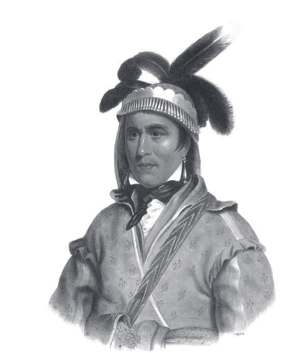
In 1804, Thomas Jefferson said of the Osage, they are “certainly the most gigantic men we have ever seen,” later adding, “the finest men we have ever seen.” That same year, at the mouth of the Osage River neasr present Jefferson City, Missouri, a member of Lewis and Clark’s Corps of Discovery wrote in his journal that they had come across the “best land he had ever seen,” that the “Osage Nation of Indians live about two hundred miles up this river. They are of a large size and well proportioned, and a very warlike people.” NPS. In 1834, during a visit to Fort Gibson, Indian Territory (Oklahoma), 19th-century painter George Catlin called the Osage “the tallest race of men in North America, either red or white skins; there being few indeed of the men at their full growth, who are less than six feet in stature, and very many of them six and a half, and others seven feet.”

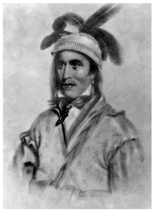
Caitlin painted these Osage warriors.

Of the Osage in Kansas little is written down.

A few names, Osage County (a name that appears to be happenstance as most of the county land was part of a Shawnee Preserve), Osage City in Osage County; some history, the Diminished Reserve for the Osage Indians in southeast Kansas, little to remind us of the Osage Indian tribe, great hunters on horses, who once roamed the prairies before this was Kansas.

For this reason I have tried to gather together a few threads of what is left.

According to oral tradition, the Osage once lived and hunted along the Ohio River Valley in an area that included Ohio, Kentucky, Indiana, and Illinois, and beyond to Arkansas where the Osage River flows into the present Lake of the Ozarks. There they discovered that the wood from the Osage orange tree, native to the area, made a strong and resilient bow. The name Osage became the name of the tree, and its French nickname, Bois d’arc (wood of the bow).

As more eastern settlers arrived, the greater part of the Osage Indian tribe moved to the Osage River in Missouri, and a smaller group, the Little Osage, to the Missouri River near the village of the Missouri Indians. Then, in 1802, before the United States acquired the Louisiana Territory from France, a third division, the “Arkansas Band,” consisting of nearly half of the Big Osage, migrated further west to lands along the Arkansas River under a chief known as Big Track (Ka-se-gra, Tracks Far Away). A treaty in 1808 and a series of treaties thereafter, resulted in the Osage ceding all claims to land in Missouri. Missouri’s statehood in 1821, accelerated the  Osage removal west to ‘Indian Territory’. Various Osage clans joined their brothers and sisters settling in what would later become Oklahoma and Kansas Territories.

Here they would  establish several villages including: Heakdhetanwan, on Spring Creek, a branch of Neosho River (near present Neosha Falls); Khdhasiukdhin, on Neosho River (Kansas); Manhukdhintanwan, a branch of Neosho River (southeastern Kansas, northeastern Oklahoma); Nanzewaspe, Neosho valley (southeastern Kansas). There is also record of their choosing to live near Pumpkin and Drum creeks on the Verdigris River in present Montgomery County (*Cutler’s History). Their peaceful life consisted of hunting, gathering and farming.

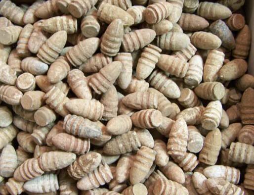
In the month of June 1860, Chief Minko Shinka, Little Bear, lead his band of Osage to their traditional buffalo hunting grounds in and among the short prairie grass along the Arkansas River at the southern edge of the Flint Hills. The trail there began in the Osage villages along the Neosho om southeastern Kansas and northeastern Oklahoma, travelling he wide stretch along what is now either Highway 400 near Beaumont, or on a more northerly path along Highway 54 and present Eureka, eventually crossing the Walnut two miles south of present El Dorado, crossed the Whitewater at Towanda, and reached the Little Arkansas, Tlo-Shusta-Shinka, west of Kechi, near present Park City.

The arrived at the settlement of John Ross and his family on the eastern bank of the Arkansas.

As a side note, Laura Ingalls Wilder’s book, Little House on the Prairie tells the story of the time between 1869 and 1870, that her family illegally spent on Osage land in Kansas, 12 miles southwest of Independence.

While there were disputes with the Cherokees because of conflicting claims to settlement land in Oklahoma, it appears that by 1872, the Osage finally relinquished all claims to land in Kansas.

Ft. Row

Nothing remains of Ft. Row. And the story is little known of the thousands of Indians who died getting there and afterwards.

ft-row-plaque

Even the site is uncertain though it is known to be on the south bank of the Verdigris River near the present town of Coyville.  Nine miles north of Fredonia on Harper Road, just as the road angles west to follow the southern bank of the Verdigris River, one comes across a commemorative plaque.

Opothleyahola

Late in 1861, Opothleyahola (Opothle Yahola), leader of a band of Creek Indian loyal to the Union, led an exodus of some 9,000 Creeks, Seminoles, and mixed Blacks and Indians, seeking refuge in Kansas from Confederate soldiers. Opposing Indian bands and Confederate Forces followed them, leading to the Battle of Round Mountain on November 19, Chusto-Talasah on December 9, and, finally, Chustenahlah on December 26.

At Chustenahlah in Oklahoma, the out-matched Creeks and Seminoles abandoned their livestock and wagons and fled for their lives in the snow and ice. Ft. Row was hastily built by Union soldiers, but it too was ill-equipped to handle such a large number of refugees. Many died on the way to Ft. Row, more died of exposure and lack of care. Many of the Indians moved on to Ft. Belmont in Woodson County. This location had only a few cabins and provided little relief.

Among the dead were , and Opthleyahola himself in 1863.

Of the surviving Indian braves, more than 1,000 made their way to Camp Hunter in Humboldt, Kansas where, along with Seminoles and African-Creeks and African Seminoles, they were inducted into the Union Army as the First Indian Regiment.  They would first see action at the Battle of Prairie Grove in Arkansas, on December 7, 1862. This battle re-established Union control of northwest Arkansas. They also saw action on the battlefields of Missouri and the Indian Territory and were mustered out in May 1865.

After the Civil War, the reconstruction treaty of 1866 required the cession of 3.2 million acres – approximately half of the Muscogee (Creek) domain.

Sharpes Rifle

A kind friend found this thoroughly flattened spent Sharpes bullet while out exploring the fields and pastures around Andover in Butler County. He kindly let me use the image for this post.

sharpes-bullet-1

Naturally, this got me to wondering how it came to be there. Here are some scenarios.

1. The breech loading Sharps rifle would play a prominent role in Bleeding Kansas during the 1850s, particularly in the hands of anti-slavery forces. The Sharps rifles earned the name Beecher’s Bibles, after famed and fiery abolitionist Henry Ward Beecher. But most of the Beechers Bibles went to Wabaunsee County, and most of the unrest took place in Douglas, Johnson, and Pottawatomie Counties, not Butler County.

Beecher's Bible

Beecher’s Bible

2. During the Civil War, the shortened barrel, carbine version of the Sharpes rifle was popular with Union and Confederate cavalries, and was issued in large numbers to combatants. In Kansas most citizens joined the Union Army. But most soldiers were drawn from eastern and northern counties in Kansas. By treaty, the southern portion of the state remained a reserve for Indians, primarily the Osage and Cherokee. Even then, some setters “jumped the gun” and staked “claims”.

sharpes-cartridges

Sharpes lead bullets

3. Lost in the the history of the Civil War is the service of Native Americans. They served in both the Union and Confederate armies. Cherokees and Creek tribes in particular were deeply divided in their loyalties. One Creek faction was chased from Oklahoma into Kansas by southern sympathizing Indians. They endured great hardship at a place called Ft. Row. Many died. Many of those that lived, joined the Union Army and, no doubt, were issued Sharpes rifles. But most of this took place in Wilson County.

4.  During the 1840s and 50s, the buffalo was hunted in Kansas for its hide and for sport. The Sharps rifle was the favorite among buffalo hunters because of its long range accuracy and in its carabine version it was easy to carry on a mounted horse. But most buffalo hunters ranged to the north in the Saline Valley near present day Manhattan, not Butler County.

5. Osage Indians roamed the Great Plains and hunted buffalo for millennia. Conflict with eastern settlers moved the tribe from Missouri to Arkansas, then, by 1825, to Oklahoma and Kansas. Walnut Valley and Arkansas Valley experienced the migration of millions of buffalo in the spring and fall. Traditionally, the Indians hunted with bow and arrow, but by the 1850s and 1860s, the Osage acquired Sharpes rifles to hunt buffalo. In 1864, James Mead opened a trading post in Towanda, and another at the mouth of the Little Arkansas River at a spot that would eventually become Wichita.

The Osage often recovered their spent cartridges to remold and reuse them with a new percussion cap and powder.

This one was lost until found.

The Creeks at Fort Row

If you head to a spot nine miles north of present day Fredonia on Harper Road, just as the road angles west on the southern bank of the Verdigris River, you will come to the location of what was once Fort Row.

Fort Row

In the first year of the Civil War, Confederate Captains John Mathews and his friend Tom Livingston led white Confederate pro-slavers, southern sympathizing Indians, and Missouri Bushwhackers in attacking Free State Humboldt in Allen County, Kansas, just northeast of Wilson County. In September of 1861, Union Forces found Matthews and  killed him.

On October 14, 1861, in retaliation, the Missouri Home Guard returned to Humboldt and burned the town to the ground.

To provide some defense of those loyal to the Union, Capt. John R. Row and a force of 80 Union soldiers built Fort Row, on a spot nine miles north of present day Fredonia on Harper Road, just as the road angles west on the southern bank of the Verdigris River.

The Opothleyahola Story

Chief Opotheleyahola

Chief Opotheleyahola

Creek Indians, forced out of Alabama and Georgia in the early 1800s, came on the Trail of Tears to Oklahoma Indian Territory where they settled and established a new hopeful life.

Then came the Civil War.

In the winter of 1861, having received assurances from the Union that Indians loyal to the North would find safety and freedom in Kansas, loyal Creeks fled Oklahoma under the leadership of Opothleyahola. Thousands of Creek braves, women, and children traveled northward to Kansas and hoped for help. Along the way, they were joined by Union loyalists from other tribes as well as hundreds of slaves who had also been promised their freedom in Kansas. Twice the group was attacked by Southerners and again in December at Chustenahal (Bird’s Creek). That battle left the Indians fleeing for their lives in the bitter cold without clothing or food.

It was to tiny Fort Row that Opothleyahola and his beleaguered band fled. The small militia contingent manning the fort was overwhelmed by those seeking food and shelter. Many died that winter.

Opothleyahola settled at the Creek refugee camp near Quenemo and died on March 22, 1863. He was buried beside his daughter near Fort Belmont (two miles west of present-day Buffalo) in Woodson County, Kansas.

Indian soldier, First Indian Regiment

First Indian Regiment

The survivors eventually continued on to Woodson and Coffee Counties.

In May of 1862, approximately 1,000 Indian braves marched to Camp Hunter in Humboldt where they were inducted into the Union Army as the First Indian Regiment, both mounted and infantry.
In June of 1862, the First Indian Regiment rode to Baxter Springs accompanied by other Union Regiments. On July 3, the Indians led an attack and surprised a force of approximately four hundred Confederates under Colonel James Clarkson near Locust Grove. The combined forces of Indians and regular Union soldiers eventually captured over one hundred prisoners, including the colonel, along with supply wagons, gunpowder, and horses.
The Union Forces and their Indian allies went as far as Fort Gibson in the Cherokee Nation, near the junction of the Neosho and Arkansas rivers, from which they controlled  the road from Fort Scott to Texas.

The Full Story